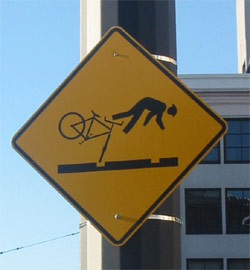
 Bikewise is place where you can mark where you have had a crash or there is a bike hazard or even more important- where things have gotten stolen. Please add to this! Great when going to new cities!
Friday, July 24, 2009
geospacial bike crash
Bikewise is place where you can mark where you have had a crash or there is a bike hazard or even more important- where things have gotten stolen. Please add to this! Great when going to new cities!


Wednesday, July 1, 2009
bubble gum fantasies
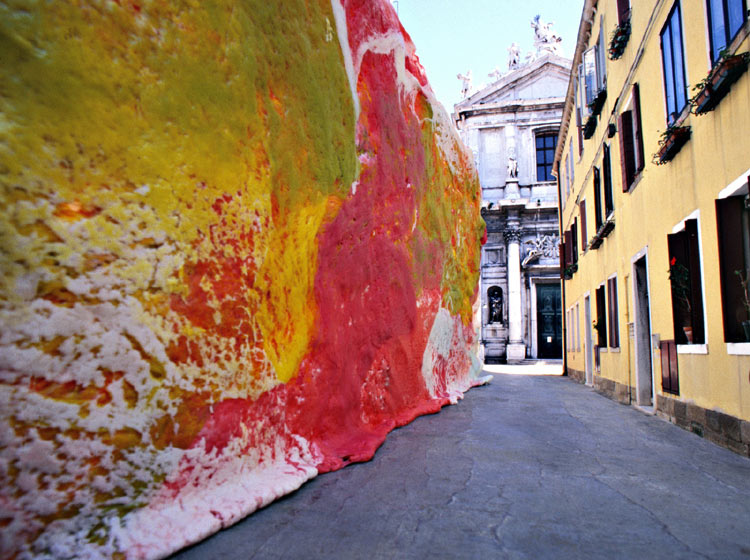 no they are not real... thanks to photoshop. but imagine if they were!....... These are by Simone Decker. I found them on a blog then got Kanye West's post about it as well.
 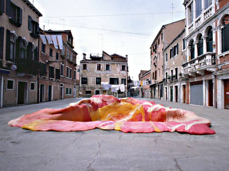 I need to restart my gum project. Here's some images from our stint in Venice beach (versus Decker's Venice Italy.)


Art delivery
 Some might think that physical systems of information dispersion might be antique with the rise of twitter, iphones, and the new Google WAVE. Buy analog production still has value on our city streets, at least in Berlin. The project called Papergirl has been recruiting young Berliner on bikes to distribute rolls of art work much like an old fashioned paper boy.
  In 2005 the city of Berlin decided to fine any one pasting posters on public spaces. Aisha Ronninger, an art student, with her colleges brainstormed about how to bring art to public urban spaces.
  They pass out art in public while riding their bikes through the city. This has now become a well-established happening in the city. Hundreds of artworks on paper are sent from all over the worlds to Papergirl team. Anyone can participate from art students to doodling taxi drivers. They just ask for a minimum of 2 artworks.
"The basic idea with the project is to bring art to the public in a different way from normal; to surprise people and bring them into contact with art in their everyday life.”
I would like to start one in LA. If you are interested in 1. being on the street team or 2. sending art, please email me. nbarbuto@gmail.com
Thanks!
Friday, June 26, 2009
WAVE hello to the future
Open sourced awesomeness! This is the future of communication. It's version of email kinda works like how you can use Google docs already. But it's waves. It's sonic booms of info. It breaks the info into particles that you can interject into, a multi level conversation. This is great to really encourage all of our ADD conditions. Yet, I think its just a step closer to singularity.
And on that topic....
And on that topic....
Thursday, June 25, 2009
Wednesday, June 17, 2009
Old men mapping the world.
GO GO GEO WEB! For all you geographers out there, the internet is coming to get you. GIS , Geographic Information Systems, can be very boring sometimes but very informative. GIS and those who deal with it make it accessible to the public via cartography and visualization. By integrating geographic knowledge into daily human interaction can help us all live more sustainable/efficiently/and even socially.
Geographic Knowledge is more than just data:
Its predictions its cartographic knowlege
Meta Data- key for discovery and access
Because of Google and other mapping systems we are all thinking spatially in real time. They need to make the knowledge for the public. At the ACADIA conference I attended last October several presentations were also on this topic. The presentation by Ginette Wessel, Remco Chang, and Eric Sauda was titled:Towards A New (Mapping Of The) CityInteractive, Data Rich Modes Of Urban Legibility.
Their paper proposes a new interactive modes of urban legibility: data space, virtual and physical city, multi-nodal, and information flows.
They conclude that two necessary aspects of any urban visualization are interactivity and the combination of data and geospatial information. Interactivity is crucial because of the fluid nature of our experience and the diversity of individual agendas in the contemporary city. The combination of data and geospatial information reinforces the importance of geometry of the city alone is no longer a reliable indicator of meaning. The modern metropolis is a lasagna of complex overlays of information. The "city as object" has been retired. As much as the city is a living and reacting system, the information that defines or at least translates these transitory systems must be defined by the mailable technology such as twitter and iphone apps.
There was a lecture that Benjamin Bratton gave this past year where he talked about open source urbanism. "For the emergent pairing of urban software and hardware, the redesign of the polis is dependent as the redesign o the city & the redesign o the city is dependent on the redesign of the software, in fact they may likely turn out to be all the same thing." He also said architecture should commit suicide. Personally I am waiting for the jump. You can watch that lecture here. Just click on the video archive link.
Nader Vossoughian gave a lecture at the Berlage Institute in January 2009 titled Open Source Urbanism and the Language of the Global Polis which you can stream here.
What I want to know is how who is mapping what is happening in Tehran right now after the election. The use of "easy tech" aka cellphones to collect the people in riots and other rebellious demonstrative movements should really be documented and theorized. The fact that Facebook was banned in the country for awhile should tell you that the Iranians really know how to use it for its potential. Until then, here's the tweets about it.
Geographic Knowledge is more than just data:
Its predictions its cartographic knowlege
Meta Data- key for discovery and access
Because of Google and other mapping systems we are all thinking spatially in real time. They need to make the knowledge for the public.
 At the ACADIA conference I attended last October several presentations were also on this topic. The presentation by Ginette Wessel, Remco Chang, and Eric Sauda was titled:Towards A New (Mapping Of The) CityInteractive, Data Rich Modes Of Urban Legibility.
Their paper proposes a new interactive modes of urban legibility: data space, virtual and physical city, multi-nodal, and information flows.
They conclude that two necessary aspects of any urban visualization are interactivity and the combination of data and geospatial information. Interactivity is crucial because of the fluid nature of our experience and the diversity of individual agendas in the contemporary city. The combination of data and geospatial information reinforces the importance of geometry of the city alone is no longer a reliable indicator of meaning. The modern metropolis is a lasagna of complex overlays of information. The "city as object" has been retired. As much as the city is a living and reacting system, the information that defines or at least translates these transitory systems must be defined by the mailable technology such as twitter and iphone apps.
There was a lecture that Benjamin Bratton gave this past year where he talked about open source urbanism. "For the emergent pairing of urban software and hardware, the redesign of the polis is dependent as the redesign o the city & the redesign o the city is dependent on the redesign of the software, in fact they may likely turn out to be all the same thing." He also said architecture should commit suicide. Personally I am waiting for the jump. You can watch that lecture here. Just click on the video archive link.
Nader Vossoughian gave a lecture at the Berlage Institute in January 2009 titled Open Source Urbanism and the Language of the Global Polis which you can stream here.
What I want to know is how who is mapping what is happening in Tehran right now after the election. The use of "easy tech" aka cellphones to collect the people in riots and other rebellious demonstrative movements should really be documented and theorized. The fact that Facebook was banned in the country for awhile should tell you that the Iranians really know how to use it for its potential. Until then, here's the tweets about it.
Saturday, June 13, 2009
Subscribe to:
Posts (Atom)

This work by Nina Marie Barbuto is licensed under a Creative Commons Attribution-Noncommercial-Share Alike 3.0 United States License.